 Lackawanna
County, Pennsylvania
Lackawanna
County, Pennsylvania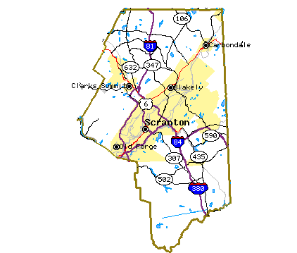
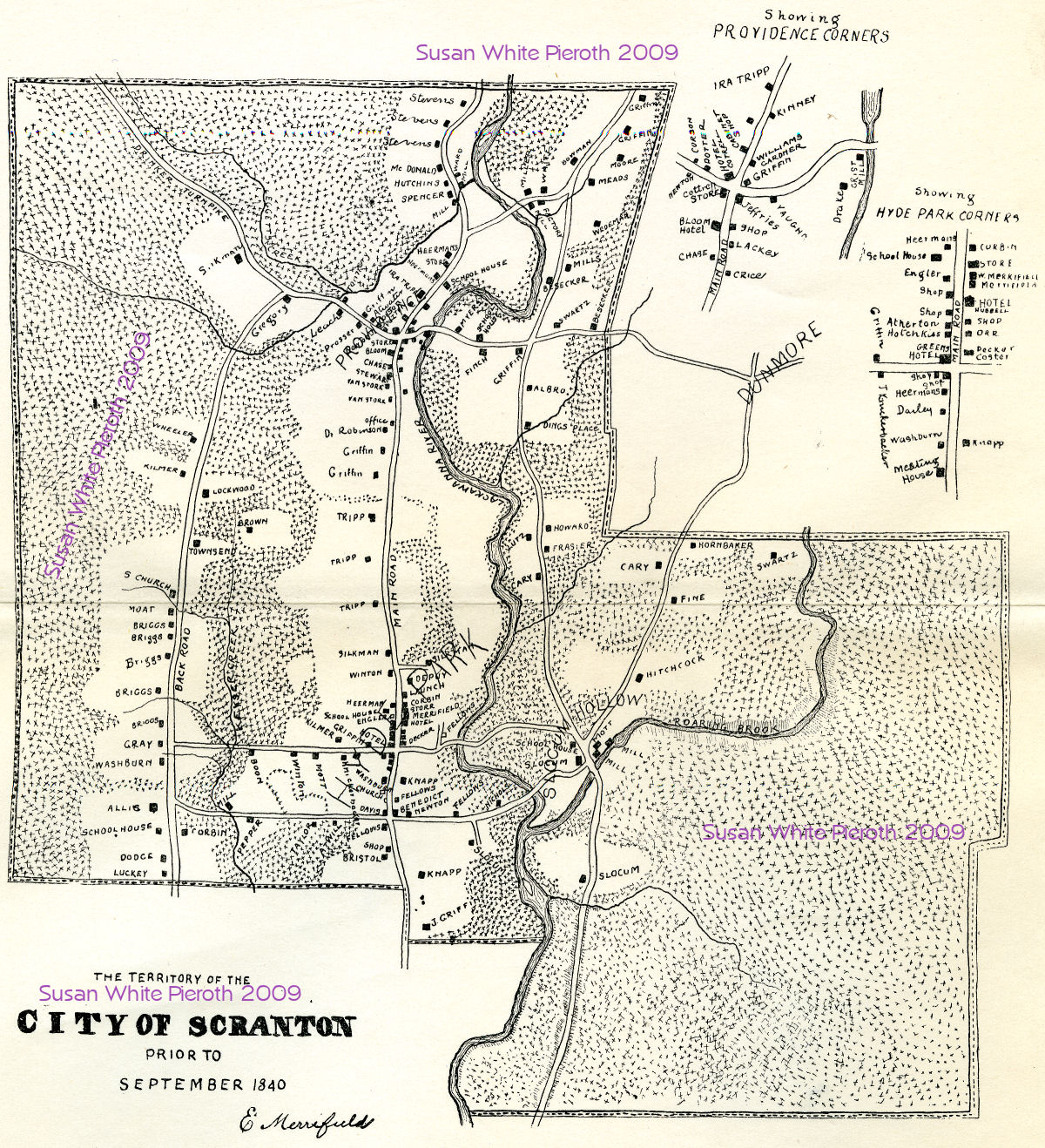 This map accompanied a fifteen page article titled, "The
Territory of
Scranton Immediately Prior to the Lackawanna Iron and Coal Co.
Purchase." By Edward Merrifield, October 1895. In addition to
Scranton,
a
detail of Providence Corners and Hyde Park Corners is shown. Slocum
Hollow is labeled to the left of the right section.
This map accompanied a fifteen page article titled, "The
Territory of
Scranton Immediately Prior to the Lackawanna Iron and Coal Co.
Purchase." By Edward Merrifield, October 1895. In addition to
Scranton,
a
detail of Providence Corners and Hyde Park Corners is shown. Slocum
Hollow is labeled to the left of the right section.
Click the image for a larger version, Click Here, for a 2 MB version.
 Eastern section of Pennsylvania, enlarged 150% (413 KB), Click
map to see
Eastern section of Pennsylvania, enlarged 150% (413 KB), Click
map to see
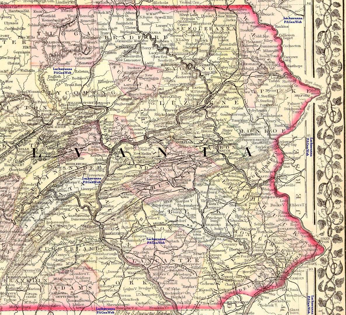
Section of Pennsylvania, enlarged 200%, that now is Lackawanna County and surrounding counties.
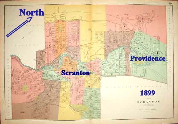
1874
Scranton map (182
KB) showing the numbered ward boundaries,
as well as the
location of Forest Hill and Dunmore Cemeteries (upper right corner),
and
the railroad lines. Note that Providence is in the upper left corner,
Hyde
Park is the lower left section, and Dunmore is the yellow area at the
top
right. Just above Dunmore is Marion Avenue with Green Ridge Avenue
paralleling
it. The section of streets between these two avenues is labeled "Green
Ridge" on the map.
City of Scranton, Pennsylvania 1877 Atlas
1884 Geological map of Lackawanna County (265 KB). Besides the location of the coal, this map shows major cities, the township boundaries and names, and the railroad lines.
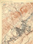 Topographical map of Scranton,
and most of Lackawanna County,
in 1889. This is a U.S. Geological Survey Reconnaissance Map
done in
1889
and reprinted, February 1909. Besides land contours and elevations,
towns,
railroad lines and major city streets are shown.
Topographical map of Scranton,
and most of Lackawanna County,
in 1889. This is a U.S. Geological Survey Reconnaissance Map
done in
1889
and reprinted, February 1909. Besides land contours and elevations,
towns,
railroad lines and major city streets are shown.
Section 1; Section 2; Section 3; Section 4The above map enlarged to show all the detail in eight sections. Each of these is a larger graphic (about 600 KB) than the first, and will take time to download.
Top Row: Section 1; Section 2; Section 3; Section 4
Bottom Row: Section 5; Section 6; Section 7; Section 8
 |
This map is by A. B.
Dunning, Jr., Street Commissioner,
copyrighted by Julius Bien & Co. N. Y. It shows the wards,
railways,
schools, churches, municipal buildings, collieries, culm piles, larger
manufacturing sites, larger cemeteries, and other prominent features.
It
is enlarged to show detail. Because the orientation is not north and
south, the image at the left is provided as a guide. For a full size of the whole map, pieced together from six overlapping scans, there are two options. Some things along the overlaps may not be legible - see the individual sections. Very large (created from the large sections below) click here - about 3.5 MB Reduced version of the above, click here - about 1.5 MB |
Larger (over a megabyte each) sections:
Top Row A: Section
1; Section
2; Section
3
Middle Row B: Section
1; Section
2: Section
3
Bottom Row C: Section
1; Section
2; Section
3
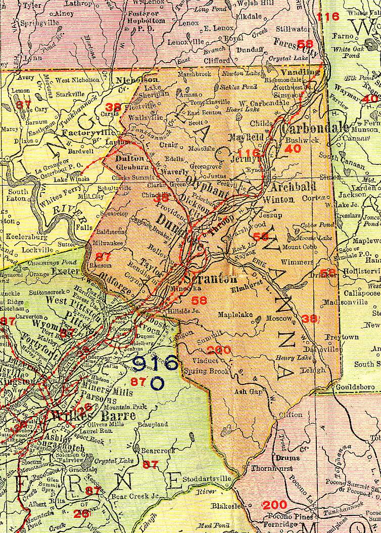
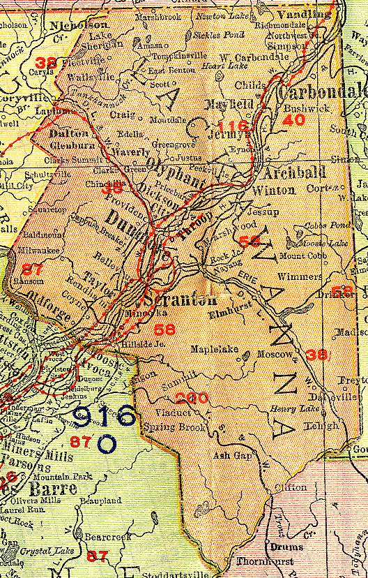
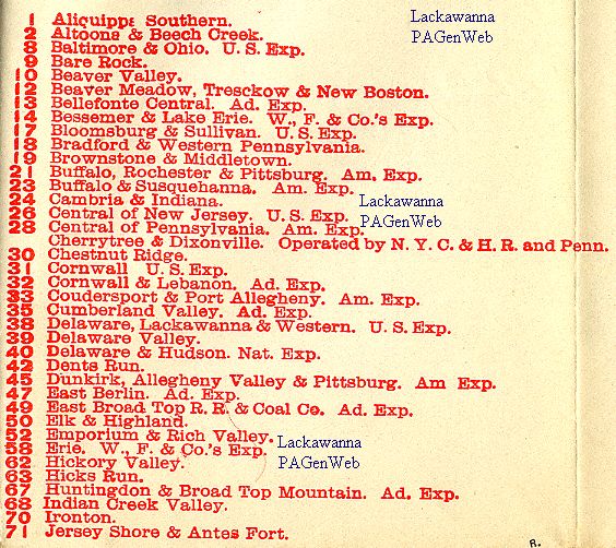
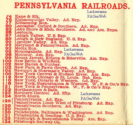
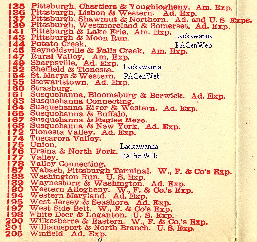
Eastern portion of Pennsylvania
with Lackawanna
County centered (246 KB).
The same
map trimmed for printing. The numbers in red refer to the
railroad
lines. The keys to these numbers (not all numbers were used) are: 1
to 71; 74-134;
135-205.
Electric Lines are shown as a solid red line with dots.
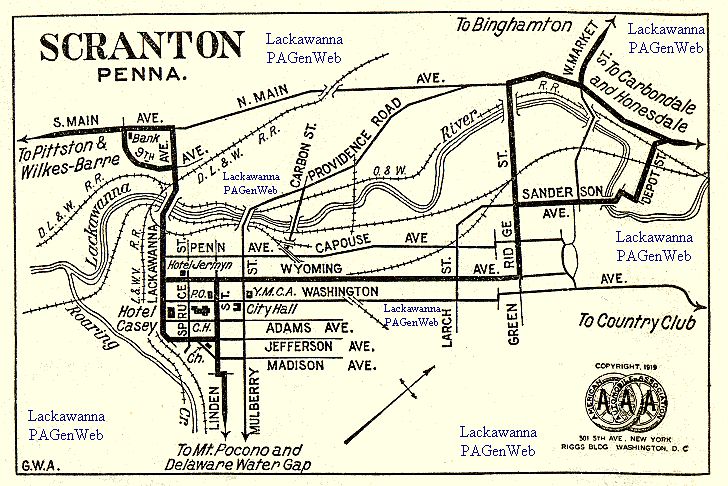
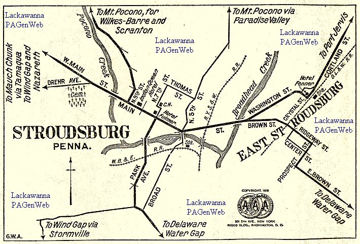
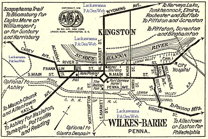
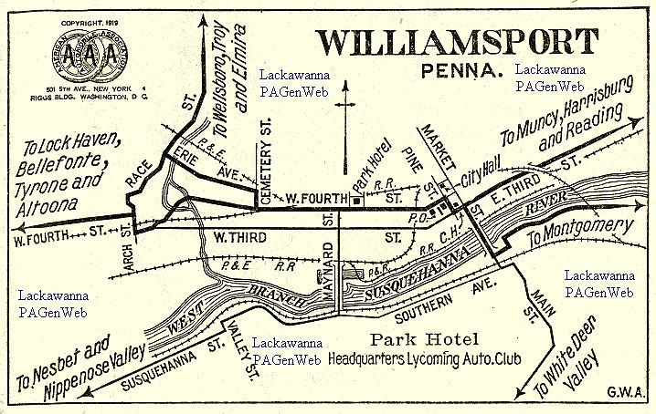
Enlarged maps of Scranton, Stroudsburg, Wilkes-Barre, and Williamsport.
Lackawanna County Highlighted Google Map - Zoom In
Origins of Town and Place Names of Northeastern Pennsylvania
Search USGS (GNIS) Geographic Names Information System
Modern Topographic Map of Scranton - with Political Features - Can Be Enlarged
Relief Map of PA with Counties Outlined
1920 Map of Scranton - good detail
Library of Congress Map Collections
Return
to the Lackawanna County
PAGenWeb Home Page
This document and information is made available free to the public for non-commercial purposes by the Lackawanna County, PAGenWeb Project.