 History of Lackawanna County, PAHistory of Lackawanna County, PA
The name, Lackawannock or Lackawanna, is derived from the Delaware Indian language, and it has come to its present form through many corruptions. One historian has written, "Lee-ha-ugh-hunt or Lee-haw-hanna. The prefix Lee ha or Lee haw, signifies the point of intersection; hanna, as in Susquehanna, Tobyhanna, Toppahannock, Rappahannock, Tunkhannock, and Tunkhanna, implies, in Indian language, a stream of water." Hence, the original meaning of the word Lackawanna, is the place where two streams meet, and it was applied to the locality at the confluence of the Susquehanna and Lackawanna rivers. From this the river took its name, as did also the valley through which it runs, and ultimately the county which includes it.
The First Settlement.
The first settlement in the territory which is now included in Lackawanna county, was made by John Gardner in 1769 in Ransom township near the mouth of Gardner’s creek.
About the same time Topez [sic] Williams, Silas Parks and Prince Alden settled in Lackawanna township. They were dispossessed by the Pennamites in 1770.
Pioneer Industries of the County
The first grist- and saw-mills in the county were built by the twon (then Pittston but now Lackawanna township) in 1774, just below the falls on the Lackawanna river. In 1775 they were sold to Solomon Strong, and soon afterward were destroyed by a flood.
Another grist-mill was built by Philip Abbott on Roaring brook in 1788. The construction of this establishment was very simple. In October of the same year his brother, James, joined him in the enterprise, and in the spring of 1789 the firm was further strengthened by the admission of Reuben Taylor, when the mill was enlarged. Later they sold to John and Seth Howe, who in July, 1798, sold the same with improvements, to Ebenezer Slocum and James Duwain.
It is recorded that James Van Fleet (from whom Fleetville was named) made and sold nearly all the plows used in the first agriculture of the valley. He made plow-shares of gnarled knots of trees for a score of years or more. He lived to an extreme old age.
Large numbers of sheep were raised in the early days of Providence township, and the inhabitants, depending wholly upon their own woolen goods for raiment, early gave attention to carding and fulling-mills. The hardy pioneer women were ever busy in dealing out their warp and filling for frocks, coats, trowsers and flannel petticoats. These mills were regarded as equally important for the prosperity of the neighborhood as the grist-mill and the saw-mill. A carding and fulling-mill was built a little from Providence in 1808 by John Watres, which passed into the hands of Carter & Miller in 1841. The earlier exports of Providence were grain, lumber and whiskey. Of the latter a large quantity was manufactured at Tripp’s still, half a mile below the village.
During 1826 Colonel Henry W. Drinker, of "Drinker’s
Beech" gave a brisk
impulse to the village when he, with trifling State aid, crossed the
valley
with the Philadelphia and Great Bend turnpike, and opened communication
with New York city by a tri-weekly stage. Passengers could then go from
Providence to New York by way of Stroudsburg in three days. The
Lackawanna
was first bridged here by Drinker in 1826.
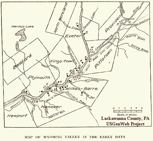 |
| The above map shows the location of the first five
original townships
laid out in the Wyoming Valley in 1768 by the Susquehanna Company
(Wilkes-Barre
or Wyoming, Hanover, Plymouth, Kings-town and Pittstown) and the
position
of the Forts, Indian villages, and other historical places of the early
days and settlement of Wyoming. The Forts are indicated on the Map with
figures, and the Indian villages, battle fields, islands, etc., are
marked
with letters as follows:
(1), marks the site of Shawnee Fort, where a garrison composed of old men, with the women and children of the neighborhood were stationed before and during the Wyoming Massacre; (2), Stewart's Block-house; (3), Fort Durkee; (4), Fort Wyoming; (5), Wilkes-Barre Fort; (6), Ogden's Fort, and later the site of Mill Creek Fort. The first settlement in Wyoming Valley was made here; (7), Forty Fort; (8), Wintermoot's Fort. The Wyoming Massacre was near this spot; (9), Jenkins' Fort; (10), Pittston Fort; (11), Fort Defense. (A), Plunkett's Battle, Dec. 24, 1775; (B), Nanticoke Indian village; (C), Shawanese Indian village; (D), Indian village of Maughwanwame (Wyoming); (E), Mohigan Indian village; (F), Wanamese Indian village (Jacob's Plains); (H), Delaware Indian village, Asserughnes; (I), Fish Island; (K), Kingston; (L), Monocacy Island; (M), Wyoming Monument; (N), Queen Esther's Rock; (0), Fuller's Island, the largest island in the Susquehanna in the Wyoming Valley. As early as 1787 it contained about fifty acres. Later it was known as Richards' Island. (P), Monsey Indian village; (R), Indian burying ground; (S), where John Gardner settled in 1769 in what is now Ransom township; (T), place where John Gardner was captured by Indians, July 1, 1778. The townships contained 16,000 acres each. The name Wilkes-Barre, in the early days was written with but one capital and without a hyphen. |
BENTON. This township was formed from Nicholson in 1838, and was named in honor of the late Hon. Thomas H. Benton, a United States senator from Missouri. This township was first settled in 1810 or 1811 by a Mr. Bassett, after whom Bassett pond is named. He located at the mouth of Bassett creek near Wallsville. At the head of Finn pond was the old camping ground of the Indians. It lay on the trail from the head waters of the Lehigh to Great Bend, on the Susquehanna. Here have been found large quantities of arrow-heads, stone hatchets, and other relics. The pioneer nurserymen were Isaac Doud and Parmenus in the northeastern part of the township. The pioneer school-house was built of logs about 1820, in the northeast corner of the township. The population of the township was 1,055 in 1870; 1,148 in 1880; 1,052 in 1890; 1,042 in 1900; 807 in 1910.
CARBONDALE was formed in April, 1831 from a part of Blakely and Greenfield townships. The wild land of this township was originally owned by an Englishman named Russell, living at Sunbury. It was named Carbondale by William and Maurice Wurts, of Philadelphia, who came into possession of it in 1812. Including the city of Carbondale it contains about twenty-three square miles. The pioneer settler was David Ailsworth, who came from Rhode Island in 1802, and located on the side of the mountain. Mrs. Ailsworth was the pioneer weaver. Peter Wedeman located on "Ragged Island" in 1807, where he raised a large family. His attire was very imposing. He wore a bear-skin for a coat, the fore legs serving for sleeves; a fawn-skin vest, buckskin pants, and a raccoon skin cap with the tail hanging behind when worn. Christopher E. Wilbur came from Dutchess county, N. Y., in 1810, to manufacture the old fashioned wooden spinning-wheels used at that time. Nearly every fireside in the valley was soon gladdened by the hum of his wheels. The population was 721 in 1870; 1,163 in 1880; 1,784 in 1890; 1,440 in 1900; 1,635 in 1910.
CLIFTON. This township was formed from Covington, December 14, 1875. Jacob Gress, the first settler, located here in 1840. He opened the first tavern in the log-house in the most primitive style. He was a brave hunter, and was the proud owner of seventy-three bear skins. He also killed over seven hundred deer and a large number of panthers and wolves, and much small game. The first store was built in 1863 or 1864 by Herbine, Baum & Co., at Clifton. The population was 282 in 1880; 172 in 1890; 200 in 1900; 203 in 1910.
COVINGTON. The township of Covington was formed in 1818 from the township of Wilkes-Barre, and embraced at that time the whole of Henry Drinker’s possessions in the south part of old Luzerne county. It was named Covington at the suggestion of H. W. Drinker, (son of Henry Drinker) in honor of Brigadier General Covington, who fell at the battle of Williamsburg, in upper Canada. In 1787, Henry Drinker purchased 25,000 acres, including this township, of the State, which has since been know as "Drinker’s Beech," from the timber that covered it. In the summer of 1814 this land was resurveyed by Jackson Torrey of Bethany, Wayne county, into lots averaging one hundred acres each. Lots were sold at $5 per acre on five years credit, the first two years without interest; payment to be made in lumber, shingles, labor, produce, or anything the farmer had to spare. The first settlement was made in 1815, by H. W. Drinker. The celebrated "Drinker Turnpike" was built through this township in 1828, its course being due north and south. The charter for this road was obtained in 1819. Its terminal points were Philadelphia and Great Bend. In 1827, when Edward Wardell, Jr., was township collector, the duplicate amounted to only $96. The territory embraced in the township at that time covered the present townships of Covington, Lehigh, Clifton, Spring Brook, Madison, and Buck township in Luzerne county. The population was 1,182 in 1870; 881 in 1880; 884 in 1890; 794 in 1900; 641 in 1910.
FELL. This township was first settled in 1818 by Peter F. Ball who came from the State of New York, building a log-house in the north-western part of the township. This township was formed from Carbondale township, in November, 1845, and named in honor of Judge Jesse Fell, who acquired considerable fame in the Wyoming valley during its early history. A coal mine was opened on Elk creek in December, 1864 by J. W. and J. P. Williams, and the breaker built in 1874, having a capacity of one hundred tons per day. The Elk creek mine was opened and the breaker built in 1873 by Clarkson & Brennan. The population was 343 in 1870; 441 in 1880; 1,154 in 1890; 2,404 in 1900; 4,353 in 1910.
GREENFIELD. This township covers about twenty square miles, and was formed from Abington in January, 1816. Among the pioneer settlers were Elijah Hobb and James Sackett, from Vermont, the latter locating in the western part of the township about 1800. Charles Berry opened the first tavern about 1820 near Carey’s Corners, which was a log-house one-and-a-half stories high, with one low room below for the guests and a little lower room above for the family. The floor between as well as the roof was made of bark. Meals were served for 12½ cents, and lodging was only 6 cents. Rum was 3 cents and gin or brandy 4 cents a glass. The pioneer schoolhouse was built in 1820. The population was 819 in 1870; 821 in 1880; 673 in 1890; 681 in 1900; 590 in 1910.
JEFFERSON. Although Jefferson Township was only formed in 1836, from Providence township, its settlement dates back to 1781 or 1782, when John Somers made a clearing at the foot of Cobb’s mountain. In 1784 he sold to As Cobb, who became the first permanent settler. For many years his cabin was the only habitation between Dunmore and the Little Meadows, in Wayne county, which offered hospitality to all passing between Connecticut and the Wyoming valley, and became one of the most popular stopping places on the whole route. The population was 776 in 1870; 194 in 1880; 696 in 1890; 750 in 1900; 633 in 1910.
LACKAWANNA. This township was formed in January, 1839, from portions of Pittston and Providence townships. It was settled as early as 1769 or 1770 by Topaz Williams, Silas Parks and Prince Alden, Connecticut Yankees, who were dispossessed by Pennamites in 1770. Barnabas Carey built the first log-cabin erected by a white man above the falls of the Lackawanna. The first saw and grist mills in Lackawanna county were built by the town (then Pittston) in 1774, just below the falls on the Lackawanna river. In 1775 they were purchased by Solomon Strong and soon afterward were destroyed by a flood. The population was 5,822 in 1880; 8,061 in 1890; 5,623 in 1900; 2,756 in 1910. Moosic and part of Taylor boroughs were formed from Lackawanna township since 1890.
LEHIGH. When Lackawanna county was formed of Luzerne county, August 13, 1878, the line ran through Buck township, dividing it in nearly equal parts, and that portion lying east of the line in Lackawanna county was formed in a new township and named Lehigh, from the river. The pioneer settler was Isaac Lewis, who came in 1842 and purchased land of Charles Terwilliger along the Lehigh river. The first year he cleared thirty acres, planted it all to corn, and raised the first crop in Lehigh. He was the first man married in the township. Gouldsboro is the only village in the township, which was made a borough May 12, 1871. The population of the township was 193 in 1880; 146 in 1890; 129 in 1900; 119 in 1910. It is settled only along the Lehigh river.
MADISON. This township was formed Aug. 7, 1849 from parts of Covington and Jefferson, and was named in honor of James Madison. The pioneer settlers, Thomas Biesecker and Richard Edwards, located in the northwest part of the township, in the fall of 1824, where they built log cabins, moving their families into them in January, 1825. The population was 1,530 in 1870; 1,041 in 1880; 1,257 in 1890; 1,242 in 1900; 640 in 1910. The borough of Moscow has been organized from a part of Madison township since 1900, with a population of 650.
NEWTON. Until 1842 this township was a part of Falls township. In that year Wyoming county was formed from Luzerne, the easterly line of the new county running through Falls township, leaving the eastern portion without a name or an organization. This was organized into a township in 1844, and named Newton, after a town of that name which is the county seat of Sussex county, New Jersey, from where many of the early settlers came. Richard Gardner was the pioneer settler, making a clearing and building a log-house near the Ransom township lone in 1803. The population was 1,057 in 1870; 1,027 in 1880; 1,059 in 1890; 1,281 in 1900; 1,417 in 1910. The inmates of the Hillside Home are included in the above.
NORTH ABINGTON. In 1867 this township was formed from Abington. In the Connecticut claim and survey this township was called Ebbington, in honor of Col. Ebbings, an extensive land agent of Connecticut, through whom titles to these lands were obtained on very reasonable terms; but these titles proved illegal and hence valueless, under the Pennsylvania laws which finally obtained, and the land holders, being indignant, changed the name to Abington. Under the Pennsylvania laws this was included in a large tract called Tunkhannock. In 1806 a new township was formed from Tunkhannock including this tract, and the name Abington was restored. This included several of the surrounding townships. In 1814 a part of Abington was annexed to Nicholson, and in 1816 Greenfield township was taken off. The township was divided in 1867 into North and South Abington. The contention of the "Yankees" and "Pennamites" retarded the early settlement of Abington, as did the large and almost impassible mountains on the south. The township remained an unbroken and unknown wilderness until about 1796, when it was surveyed by a party form [sic] Rhode Island under the Connecticut claim. In 1799, Deacon William Clark and family (including his three sons, William, Jeremiah and John), Thomas Smith and Ephriam [sic] Leach came from Connecticut. Their outfit consisted of one poor horse, a drag made of poles fastened at the back of the horse for a conveyance. On this drag were placed a sap kettle, their axes, and a few clothes and provisions. They crossed the Leggett mountain, at a gap westerly from where the road now passes. They made their camp in Abington, March 15, 1799. During the summer and fall they made clearings in several places and opened a path through Leggett’s gap. Deacon Clark settled at what is now Clark’s Green, a name given in his honor. The first teacher, preacher and postmaster was Elder John Miller. The population of North Abington township was 1,072 in 1880; 1,090 in 1890; 362 in 1900; 319 in 1910. Dalton borough and West Abington township were organized from parts of North Abington township since 1890.
RANSOM. This township was formed in 1849, from parts of Exeter and Newton. It was named in honor of Captain Samuel Ransom, who raised a company in 1777 for the defense of Wyoming valley, and fell in the Wyoming Massacre, July 3, 1778. The pioneer settler, John Gardner (also first settler in Lackawanna county), came from Colchester, Conn., in 1769, and built a log cabin along the Susquehanna, near the mouth of Gardner’s creek. The population was 646 in 1880; 650 in 1890; 894 in 1900; 849 in 1910. The above figures include the inmates of the Ransom Home.
ROARING BROOK township was formed May 24, 1871, out of parts of the borough of Dunmore and the townships of Jefferson and Madison, and named from the stream passing through it. Before and after the construction of the Drinker turnpike through the township there had been no settlement, unless we count Barney Carey, who kept the toll-gate on the turnpike about a mile below Dunning. Gilbert Dunning located at that village in 1847. He raised the first crops in the township. A few years later he erected the first framed house in the township. The first school-house was built in 1855. The population was 769 in 1880; 335 in 1890; 213 in 1900; 235 in 1910.
SCOTT. This township was formed from Greenfield in 1846, and named in honor of Hon. David Scott, one of the associate judges of Luzerne county. This is one of the townships across which the Indians traveled from Susquehanna to the head waters of the Delaware. One of the camping grounds was near Scott village. Roger Orvis, from Vermont, located in 1802 at Orvis Corners. He made the first clearing and built the pioneer log cabin. The first grist-mill was built of logs by Seth Howe, in 1800, at the outlet of Chapman’s Lake. It had but one run of stones. The water was conveyed from the outlet through troughs of logs to an overshoot wheel. The township had a population of 1,132 in 1870; 1,263 in 1880; 1,213 in 1890; 1,255 in 1900; 1,296 in 1910.
SOUTH ABINGTON. At a special meeting held in the southern district of Abington, Oct. 8, 1867, 100 votes were cast in favor of a division of the township, and 24 against. A majority being in favor of division in both districts, it was carried into effect on the 25th day of November, 1867. The population was 923 in 1880; 1,083 in 1890; 1,1612 in 1900; 1,987 in 1910. (See North Abington township).
SPRING BROOK. This township was formed from Covington, Nov. 22, 1853. The north half was originally owned by Dr. Hoosie and the south half by a Mr. Fisher, except 800 acres at Yostville, owned by H. W. Drinker. The first settlement was made in 1832 by Abraham Turner, near the centre of the township. The pioneer school-house was built in 1832. It was a framed building, and the first teacher was Miss Emeline Griffin. The population was 426 in 1870; 658 in 1880; 756 in 1890; 458 in 1900; 439 in 1910.
WEST ABINGTON township was formed from a part of North Abington January 24, 1895. At a special election, held Tuesday, January 22, 1895, at the regular polling place of North Abington township; 81 voted for and 4 against the division of the township. Two day later the court appointed the following person electors of the said township: George H. Colvin, judge of elections; W. S. Ross, majority inspector of elections; H. E. Capwell, minority inspector of elections, and George F. Gethman, constable. The population was 219 in 1900, and 216 in 1910.
Townships Which Have Become Extinct
PROVIDENCE township was formed in 1770. It was named from Providence, R. I., and was the sixth of the townships allotted by the Susquehanna Company to the Connecticut settlers. It originally contained twenty-five square miles.
After the decree of Trenton, in 1782, Providence became one of the townships of Northumberland county which had been organized in 1772, and embraced the territory in dispute between Connecticut and Pennsylvania. Upon the erection of Luzerne county four years later, it was included with its boundaries; but it was not organized into a township of said county until 1792, when it was separated from Pittston. As a township Providence has become extinct. In April, 1819, a portion was set off as a part of Blakely; Jan. 4, 1829, the western portion was reannexed to Pittston township; March 14, 1849, Providence borough was erected from its territory; Hyde Park borough, May 4, 1852; Scranton borough, Feb. 14, 1856; Dunmore borough, April 10, 1862. The city of Scranton was incorporated April 23, 1866, which embraced within its limits all that then remained of the ancient township of Providence and the boroughs of Providence, Hyde Park and Scranton.
The first whites who settled in Providence as originally bounded, were Timothy Keyes, Andrew Hickman and Solomon Hocksey. They erected a cabin in 1771, where Taylorville now is, on the bank of the creek which has since been named in honor of Mr. Keyes. Mrs. Hickman was one of the first five women in Wyoming. The same year Isaac Tripp, one of the proprietors of the Susquehanna company, built his log cabin near the vacated wigwams of the Monsey Indians at "Capoose Meadow," and without clearing a foot of land planted and raised a crop of corn the first season, on the plantation deserted by the Indians a short time before. There were more than a score of other purchasers of land in the township between 1772 and 1775. In 1775 James Leggett emigrated from New York and located at the mouth of the creek now bearing his name. He was the first to make an improvement above Providence village. In the Connecticut Susquehanna Company’s original plat of the township this tract had been allotted to Abraham Stanton, in 1772. The next year it was transferred by Stanton to John Staples. On account of some dereliction of duty, Staple’s claim was declared forfeited, and in 1774 it was granted to Davis Thayer. When he sold it to Leggett, in June, 1775, this, with several other tracts of land in the vicinity were covered with unbroken forest. Click here for additional Providence Township history.
BLAKELY township was first settled by Timothy Stevens in 1786, near what is now Dickson City. This township was formed from parts of Providence and Greenfield townships in 1818, and is now merged into the boroughs of Blakely (1867), Jermyn (1870), Dickson City (1875), Olyphant (1877), Archbald (1877) and Winton (1877).
OLD FORGE. This
township was formed from
Lackawanna township,
May 26, 1871, and contained nearly nine square miles. Among the
pioneers
none were more prominent in business affairs and in the development of
the township’s resources, then Dr. William Hooker Smith, who
came here
in 1789, after having lived in the Wilkes-Barre clearing from 1772. He
was a competent surgeon and physician, and, excepting Dr. Sprague, he
was
the only physician in 1772 between Cochecton and Sunbury, a distance of
150 miles. He was a plain, practical man, with all the old-fashioned
faith
in the virtues of bleeding. In the Spring of 1789 Dr. Smith and James
Sutton
built a forge just above the mouth of Ascension brook, on the rocky
edge
of the Lackawanna and just below the rapids or falls. This was the only
concern of the kind in all Westmoreland, except one at Newport, built
in
1777. From it the township derived its name. Its population was 1,408
in
1880; 4,422 in 1890. Since 1890 the township has become extinct, being
merged into Old Forge borough and part of Taylor borough.
Abington, Benton, Carbondale, Clifton, Covington, Elmhurst, Fell, Glenburn, Greenfield, Jefferson, Laplume, Madison, Newton, North Abington, Ransom, Roaring Brook, Scott, South Abington, Spring Brook, Thornhurst, West Abington.
Current Boroughs
Archbald, Blakely, Clarks Green, Clarks Summit, Dalton, Dickson City, Dunmore, Jermyn, Jessup, Mayfield, Moosic, Moscow, Old Forge, Olyphant, Taylor, Throop, Vandling.
Scans of Books are on the internet. Search on http://www.archive.org/ for better quality than on Google.